ICW Information by ICW Statute Mile Marker
STM 101 to 200
Back to STM 0 - 100 Forward to STM 201-300
Updated: 12 October 2018
Hydrographs in this Section:
NOAA hydrograph on Pungo River near Belhaven
Latitude: 35.537222° N, Longitude: 76.622778° W
https://water.weather.gov/ahps2/hydrograph.php?wfo=mhx&gage=blhn7
STM: 113.9
Fixed Bridge; Fairfield
Transit reports, SV Onward:
Date | Time | HB N | HB S | EEH | Tide | Fenders | Comment |
24-Oct-16 | 1415 | NHB | NHB | ~65.0 | NTA |
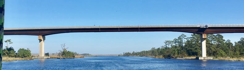
TM: 125.9
Fixed Bridge; Wilkerson
Closest Hydrograph to Wilkerson Bridge
NOAA hydrograph on Pungo River near Belhaven
Latitude: 35.537222° N, Longitude: 76.622778° W
https://water.weather.gov/ahps2/hydrograph.php?wfo=mhx&gage=blhn7
Transit reports, SV Onward:
Date | Time | HB N | HB S | EEH | Tide | Fenders | Comment |
1-Nov-10 | 64.5 | 64.5 | ~64.75 | NTA | |||
24-Oct-16 | 1545 | 64.0 | 64.0 | >64.25 | NTA | Note: Belhaven Hydrograph = +0.6' |
Notes:
- The Wilkerson bridge is the most problematic fixed bridge on the northern section of the ICW.
- The listed clearance for this bridge is 64.0' [What were the USCG and the Corps of Engineers doing when this was built???]
- Onward in 19 trips has consistently found this bridge to have the lowest clearance along the northern ICW.
- There is a NOAA hydrograph at Belhaven which is the closest hydrograph to the Alligator River-Pungo River Canal and the Wilkerson Bridge; it is useful to estimate wether water levels may be too high to transit the bridge.
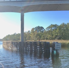
Wilkerson Bridge 24 Oct 16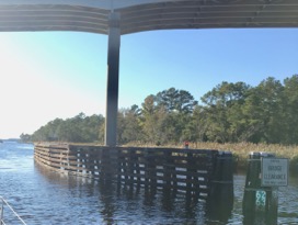
Wilkerson Bridge 24 Oct 16
STM: 157.0
Nav. Marker / Location: USCG Station Hobucken
Note: W side.
STM: 157.1
Fixed Bridge; Hobucken
Note: Vertical Clearance: 65'M: 157.5 - approximate\
Transit reports, SV Onward:
Date | Time | HB N | HB S | EEH | Tide | Fenders | Comment |
2-Nov-10 | - | NHB | NHB | >65.75' | |||
25-Oct-16 | 0945 | NHB | NHB | >65.75' | 0.8 @ Core Creek | ||
STM: ~157.3
Nav. Marker / Location: SW of Hobucken Bridge; W side of channel
Vessel Reporting: Onward
Date: 2 Nov 10
Report: A vessel in front of Onward strayed just off the centerline of the channel to the W (but still visually well in the channel), encountered an underwater obstruction / shoal and grounded. It was able to back off. Suggest vessels favor the E side of the channel in this area
STM: 195.9
Fixed Bridge; Core Creek
Transit reports, SV Onward:
Date | Time | HB N | HB S | EEH | Tide | Fenders | Comment |
26-Apr-16 | 0900 | 66.0 | 66.0 | >65.75 | - | ||
25-Oct-16 | 1415 | 65.75 | 65.75 | >65.75 | 1.0 @ Core Creek | ||
Back to STM 0 - 100 Forward to STM 201-300